

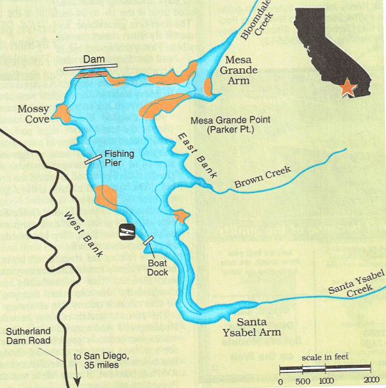
Sutherland Lake Fishing Map, Fishing Report, Hunting Clubs, 2019 private fishing nearby
Sutherland Lake Fishing Map,
How to fish this lake
Fishing Report and fishing map
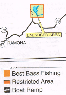
Best Areas Where to Fish
San Diego Hunting Clubs and Ranches
Information: Recorded message available at (619) 465 3474. San Diego Water Department may have some additional information at (619) 668-2050.
How to Fish Sutherland Lake and Fishing Report
Click on a county for Hunting Clubs & Private Ranches:
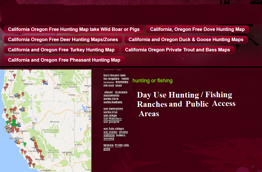
If you like our Fishing map and information on how to fish this lake, we have many more hunting and fishing maps, here is a screen shot, but if you want more info, click on this link:
www.freehuntfishmaps.com
Also, if you want very specific county by county information on fishing and hunting clubs in California and Oregon for private fishing, hunting clubs, and exclusive network of hunting ranches found nowhere else, here is a screen shot below, click on this link to go to the site:
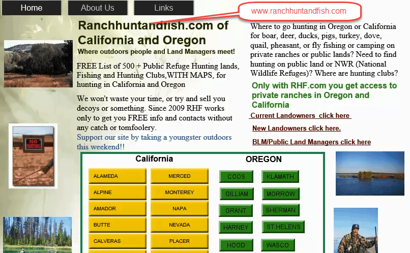
www.ranchhuntandfish.com
California and Oregon for private fishing, hunting clubs, and exclusive network of hunting ranches
we have many more fishing maps and hunting maps at www.freehuntfishmaps.com
Recent Posts
-
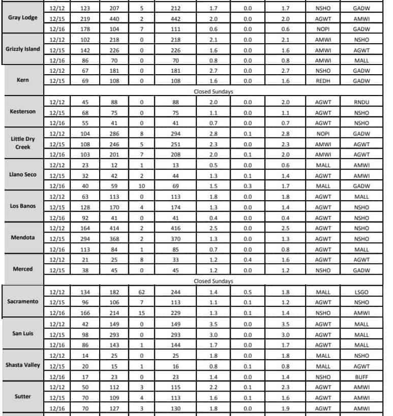
 Latest Refuge results for California Duck and Goose
 2018 California Refuge Average Kill Totals and Results Latest update on refuge counts for Colusa, Grizzly, Grey Lodg...
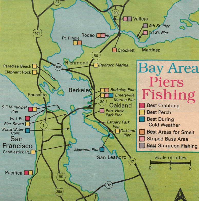
- SAN PABLO, SAN FRANCISCO BAY FISHING PIER MAPS AND INFORMATION
[sg_popup id="2" event="onload"][/sg_popup]SAN PABLO, SAN FRANCISCO BAY FISHING PIER MAPS AND INFORMATION BERKELEY, PACIFICA...
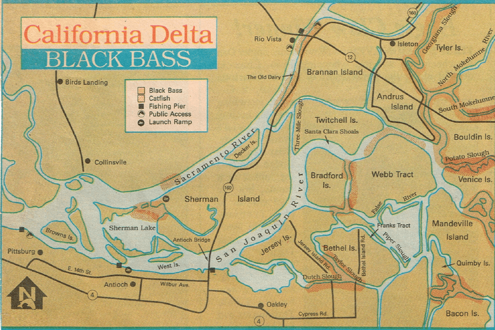
- DELTA BASS FISHING MAP WHERE LARGEMOUTH BEST AREAS TO FIND BASS
DELTA FISHING MAP WHERE LARGE MOUTH BASS BEST AREAS TO FIND BASS ALSO ACCESS TO 120 HUNTING RANCHES AND CLUBS (FISHING ON FA...
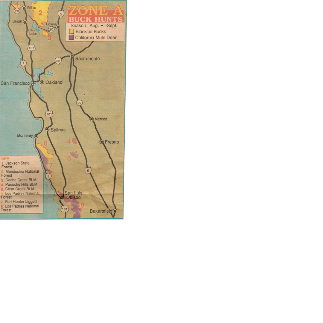
- Zone A California Hunting for Deer, best spots, Public Land Areas, Hunting Ranches and Clubs
Find your County below, or click on Map Markers on our Google Map on our Deer Hunting page to find Day use Hunting Ranch...
- Hunting Quail in California and Oregon Public Land Maps, How to hunt quail, and access Hunting Clubs and Hunting Ranches
Hunting Quail in California and Oregon Hunting Guides and Outfitters (see notices below) Best Areas Public Lan...
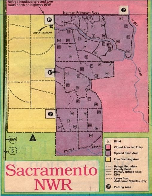
- Duck hunting Map and Report Sacramento Refuge 2019 and Duck Hunting Clubs, Duck Blind leasing and Day shoots
Duck hunting California's Sacramento Refuge 2019 - Refuge report and how to hunt Sacramento refuge - Sacramento Refuge Maps...
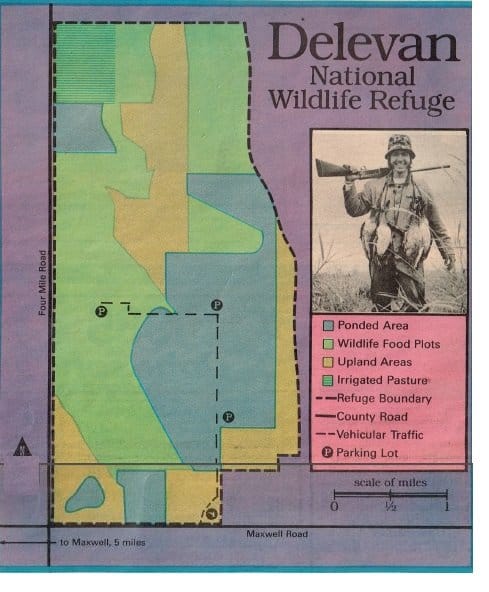
- 2019 Delevan Refuge Duck Hunting,Maps, Duck Reports, Duck Hunting clubs, how to hunt refuge
California Duck Hunting Delevan Refuge -2019 Delevan Refuge Reports - Color Delevan Refuge Maps - Local Duck Hunting C...
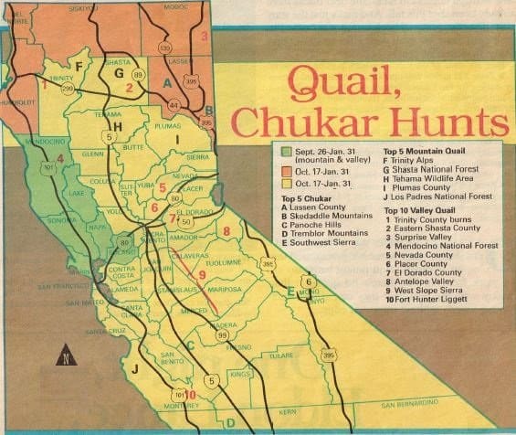
- 2019 Hunting Chukar, Quail in California and Oregon Public Land Maps, How to hunt quail, and access Hunting Clubs and Hunting Ranches
Hunting Chukar, Quail in California and Oregon 2016 Public Land Maps, How to hunt Chukar, Hunting Clubs and Ranches...
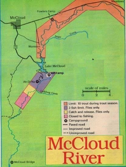
- McCloud River 2019 Fishing Report and Fishing Map, local hunting public areas, clubs
Best Areas of McCloud River and 2019 Fishing Report and Fishing Map with Hunting Club and Private Hunting Ranch inf...
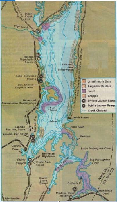
- 2019 Lake Berryessa Fishing MAP and Fishing Report, and Napa County Hunting Clubs
Lake Berryessa Trout and Bass Fishing Map & Fishing Report, How to Fish Lake Berryessa 2016 Lake Berryessa T...
Please click on a County for Fishing and Hunting Clubs, Ranches or the Best Public Land Areas
| ALAMEDA HUNTING FISH | ALPINEHUNTING FISH | AMADORHUNTING FISH | BUTTEHUNTING FISH | CALVERASHUNTING FISH |
| COLUSAHUNTING FISH | CONTRA COSTAHUNTING FISH | EL DORADOHUNTING FISH | DEL NORTEHUNTING FISH | FRESNOHUNTING FISH |
| GLENNHUNTING FISH | HUMBOLTHUNTING FISH | IMPERIALHUNTING FISH | INYOHUNTING FISH | KERNHUNTING FISH |
| LASSENHUNTING FISH | LAKEHUNTING FISH | LOS ANGELES HUNTING FISH | MARINHUNTING FISH | MENDOCINOHUNTING FISH |
| MONTEREYHUNTING FISH | MERCEDHUNTING FISH | NAPAHUNTING FISH | PLACERHUNTING FISH | RIVERSIDEHUNTING FISH |
| SACRAMENTOHUNTING FISH | SANTA CLARAHUNTING FISH | SANTA BARBARA HUNTING FISH | SAN BERNADINO. HUNTING FISH | SANTA CRUZHUNTING FISH |
| SAN DIEGO HUNTING FISH | SAN FRANHUNTING FISH | SAN JOAQUIN HUNTING FISH | SAN LUIS OBISPOHUNTING FISH | SHASTAHUNTING FISH |
| SISKIYOUHUNTING FISH | SOLANOHUNTING FISH | SONOMAHUNTING FISH | TEHAMAHUNTING FISH | TRINITYY HUNTING FISH |
| YOLOHUNTING FISH | YUBAHUNTING FISH | HUNTING & FISHING MAPS | HUNTING CLUBS AND RANCHES SITE | CONTACT US |
Please click on a County for Fishing and Hunting Clubs, Ranches or the Best Public Land Areas
| COOSHUNTING FISH | GILLIAMHUNTING FISH | GRANTHUNTING FISH | HARNEY HUNTING FISH | HOOD HUNTING FISHING |
| KLAMATHHUNTING FISH | MORROWHUNTING FISH | SHERMANHUNTING FISH | ST.HELENSHUNTING FISH | WHEELERHUNTING FISH |
| HUNTING FISH | HUNTING FISH | HUNTING CLUBS & RANCHES SITE | HUNTING & FISHING MAPS | CONTACT US |
Contact Me for Newsletter
Get on our mailing list for Newsletter and to receive New Fishing and Hunting Maps and Hot Spot News in your area If you want FREE info on Hunting access and Fishing on over 200 Private Ranches and Hunting clubs, fill this out ! (We NEVER release your info to anyone not specific to this inquiry!)


